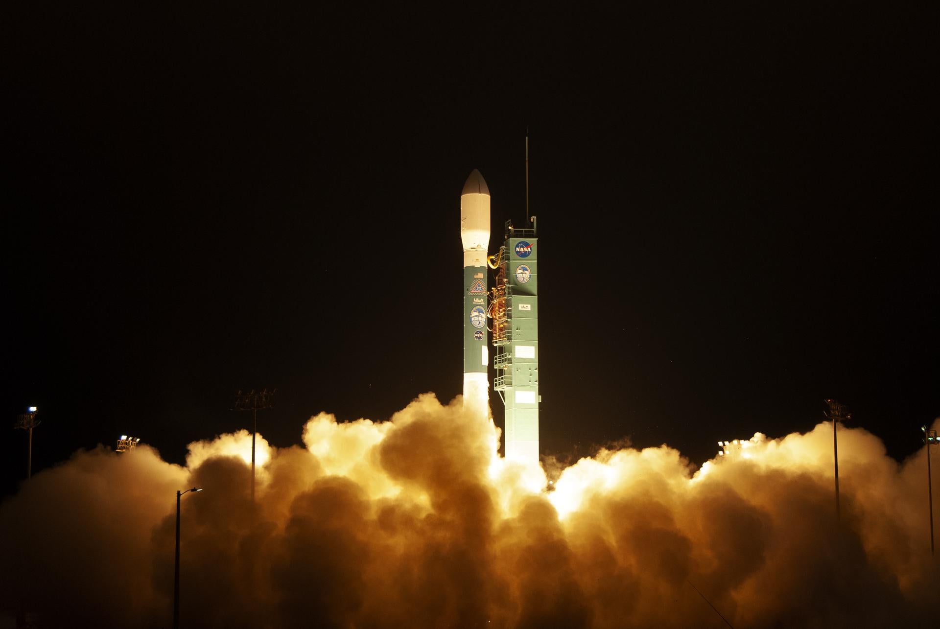
On Sept. 15, 2018, at precisely 6:02 a.m., a Delta II rocket lifted off in a cloud of fire and smoke from Vandenberg Air Force Base on the central California coast. The payload, a NASA observation satellite known as ICESat-2, measured roughly the size of an automobile, and weighed in at 3,338 pounds. At an altitude 310 miles above the Earth, the satellite decoupled from the rocket and moved into orbit. After that, its work began.
Traveling around the planet at 15,660 mph, ICESat-2 began aiming a six-beam, green-spectrum laser toward Earth’s surface. Its goal for the next three years — and perhaps as long as seven years, if its machinery continued working — would be to constantly measure the glaciers, ice sheets, sea ice, oceans, and tree canopies far below.
The launch wasn’t much of a news story. When the mission began, there was little talk of big breakthroughs or revolutionary ideas. Indeed, even the satellite’s name (it acts as a replacement for the first ICESat, which was launched in 2003 and burned up upon reentry in 2010) could give the impression that this might be a sequel that wasn’t as exciting as the original production. Since we already know so much about the planet, and especially how ice sheets in Greenland and Antarctica are imperiled by a warming climate, how much could it tell us that is truly new?
Sometimes evolution can be as important as revolution, however. An unexpected surprise is that ICESat-2 seems able to peer down into shallow waters along the North American shoreline, providing a valuable new data set. And after only a short time in orbit, the satellite and its orbiting companion, another satellite called Grace-Fo that launched just a few months earlier, have enriched our observational record of Earth’s cryosphere, or frozen regions. As climate change alters the planet in ways that are both obvious and arcane, this new generation of remote-sensing satellites is compiling a granular record of what is happening in the world’s most distant and difficult-to-reach latitudes.
“This is really the big question in understanding what’s driving the ice sheet behavior — to map out what it’s going to do in the future,” said Felix Landerer, a research scientist at NASA’s Jet Propulsion Laboratory. With better observations on hand, our models for ice sheets, which are not yet as precise as atmospheric models, can take a significant step forward.
In many respects, that’s the good news about what we’re receiving now from space. The bad news, as data from Antarctica and Greenland filters in, is that the ice sheets have never seemed so precarious.
In early 2018, a pivotal ICESat-2 tool was in the final stages of construction at NASA’s Goddard Space Flight Center in Greenbelt, Maryland. One afternoon Tom Neumann, then the ICESat-2 deputy project scientist, drove a short distance from his office to a nearby assembly building on the Greenbelt campus to take a look. A team of engineers was putting the finishing touches on Atlas, the sophisticated laser that would be carried by ICESat-2 as its essential observation tool. As Neumann explained, ICESat stood for ice, cloud, and land elevation satellite. Atlas was an acronym for advanced topographic laser altimeter system.
The Atlas laser works by sending out trillions of photons in rapid pulses. These photons travel 310 miles down to our planet’s surface, where they scatter and bounce as they hit ice, water, earth, and treetops. But a few of these photons are collected as they bounce back up to the satellite. And therein lies a crucial measurement. By timing the photons’ path from the emission from Atlas, to the surface of the Earth, and then back to the satellite in space, ICESat-2 can discern tiny elevation changes in the world below. If the ice on a glacier in Antarctica or Greenland was to melt and drop even a few centimeters in elevation over the course of a few months, for instance, ICESat-2 would notice. The same would be true for sea ice.
At the Goddard building, Neumann explained: ICESat-2 “is sending out a pulse from six beams, simultaneously, 10,000 times a second.” That’s a rapid rate, he said, noting, “if you blink your eyes it takes about half a second. In that time, Atlas will have fired its laser 5,000 times, among six beams, collecting 30,000 measurements.”
During the satellite’s orbit, this data would be downloaded on a regular schedule to a ground station in Svalbard, a small group of islands located in the northernmost reaches of the Arctic.
Neumann had little doubt that the new satellite would collect extraordinary amounts of information about the Earth’s polar regions. It also seemed obvious to him that it would be a significant improvement on the original ICESat, which took 40 measurements a second rather than 10,000. “We’re going to do better with ice sheets, we’ll do better with outlet glaciers, we’ll do better with sea ice,’’ Neumann said. “But I’m almost sure there will be something we can do with it that we never thought of before. I had a question a couple of weeks ago from somebody asking whether we could use it to measure penguin heights.” He gave it serious thought. “And I was like, yeah, actually, probably could.”
But he couldn’t actually be sure. It was still half a year before the launch. The first ICESat mission had ultimately been hobbled by a catastrophic malfunction in its lasers. Things could go wrong here, too.
Long-term data sets from satellites don’t stir the general public like the drama of a crewed mission to Mars. But in the past two decades, Earth observation satellites have arguably changed our view of how the planet is evolving more than any other technology or field-science endeavor.
The original ICESat, for instance, was conceived in the mid-1990s, and its launch in January 2003 brought on the prospect of compiling something that had never existed before: a steady measurement of changes in the elevation of ice at (and near to) both poles.
As it happened, ICESat was part of a larger strategy. The year before, NASA had launched a different satellite that was also meant for compiling a record of changes in the polar regions. This other satellite — known as Grace, which stood for gravity recovery and climate experiment — was curious in its technology and approach. Rather than use a laser altimeter to measure the surface elevation of the Earth, Grace would use variations in Earth’s gravity to measure the movement of water from one place to another. Not only would this be useful in measuring changes in Earth’s cryosphere, it could also be used to detect decreases in groundwater reserves in places like the American Southwest.
The idea was elegant in its simplicity but complex in its execution. Grace was not one machine but a pair of modules, each about the size of a small sports car, sent into orbit at an altitude of about 300 miles. One module was meant to trail the other at a distance of 137 miles. The key was that each module used an exquisitely sensitive microwave communications system to keep a precise record of tiny changes in their 137-mile orbital gap.
Even from hundreds of miles above the planet, these modules were sensitive to gravitational forces from below. When the leading module approached a part of Earth with more mass — and therefore more of a gravitational force — it was pulled ahead, literally by a fraction of the width of a human hair. But the force of that tiny pull could in turn be measured by the microwave communication link.
So as Grace passed over the massive Greenland ice sheet, for instance, the leading module would respond to gravitational forces and edge out ahead by a hairsbreadth. Over the course of thousands of orbits, by measuring the change in distance between the two modules — in essence, the change in gravitational force over time — NASA scientists could determine how much ice was being lost in Greenland and the Antarctic. By 2016, data from Grace indicated that Greenland was shedding, on average, about 286 billion tons per year. Antarctica was meanwhile losing about 127 billion. And all of that ice was falling into the oceans and raising sea levels in the process.
Satellites don’t last forever. They run out of the fuel they use — usually tanks of compressed nitrogen — to make crucial orientation corrections in space. Or they suffer technical glitches with batteries or communications equipment. Or, like the original ICESat, their measurement systems stop working properly and they need to be brought down from orbit.
Grace had an extraordinarily long run of 15 years, but it ceased working in October 2017, and was decommissioned by NASA. By that point, however, NASA had already been building a replacement in conjunction with the German Aerospace Center. The replacement satellite was called “Grace Follow-On” — or more simply, Grace-Fo. The machine was nearly an exact replica of its predecessor, and was launched into space in May 2018.
Much like ICESat-2, the new Grace was not the kind of project that seemed to stoke the public imagination. Its goal was to continue to produce a long-term record of changes here on Earth, and especially changes in the icy polar regions. What was especially crucial was to measure the Arctic, an area already warming twice as fast as the rest of the planet, and to keep an eye on Antarctica, where several huge glaciers on the western part of the continent — Thwaites in particular, which was about the size of Florida — looked to be increasingly unstable.
Along with ICESat-2, Grace-Fo began delivering data to the science community not long after launch in 2018. And since then, the second generation of Earth remote sensing satellites — including CryoSat-2, which is operated by the European Space Agency — have continued to speak, with remarkable precision, about what is happening to the Earth in places few humans ever visit.
As of mid-December, ICESat-2 has been operational for about 14 months. Neumann said recently that the satellite had so far taken about 376 billion laser “shots,” versus 2 billion in total for the first ICESat. The amount of data comprising the new observations, in other words, has already dwarfed what came out of the entire original mission. It was likewise clear, he added, that the Atlas laser on ICESat-2 was far exceeding the scientific team’s expectations.
From an altitude of 310 miles, the laser has been able to see down into crevasses in the ice sheet and measure their depth and width. At the same time, Atlas was able to range down through summer melt ponds on the Greenland ice sheet and gauge their depth, a type of measurement that pointed toward a new way to assess how much water is pooling on the ice at any given time. Given the fact that Greenland’s ice sheet underwent an extraordinary melting season this past summer, this technique may prove extremely significant in understanding how (and how much) the ice sheet melts in warmer months.
What has been especially surprising to the NASA team, though, is how ICESat-2’s laser has been able to map the shallow water near various coastlines around the world — a measurement known as bathymetry. In other words, the satellite can help create an expansive map of how deep the coastal waters run near the shore.
This may be crucial for flooding projections. A new understanding of the depths of the waters around, say, the coast of North Carolina may prove especially useful for computer modelers who try to plan ahead for storm surges made worse by heightened hurricane activity and sea level rises brought on by the retreat of glaciers in Antarctica and Greenland.
Meanwhile, the urgency of the situation in the Arctic — apart from Greenland’s summer meltdown, there has been a dramatic retreat of the floating sea ice cover in the Arctic ocean — makes the new satellite’s scrutiny all the more crucial. In recent months, a team working with NASA’s Jet Propulsion Laboratory has been analyzing data from Grace-Fo to see how many billion tons of ice were lost from Greenland in total in 2019. (By some preliminary estimates by European scientists, during a July heatwave, the Greenland ice sheet lost about 11 billion tons of ice during just one day.)
Landerer, the Grace-Fo mission’s project scientist, said he’s confident that 2019 was as big a melt as the current record, which occurred in 2012. “The final tally is still out,” he noted, yet it’s obvious to him from the data that Greenland’s ice sheet has well exceeded the average melt year, meaning its losses were probably equal or larger than 300 billion tons.
What seems to be emerging from ICESat-2 and Grace-Fo is more than data, however. The two upgraded sensing missions work in a complementary manner toward a larger purpose. In measuring the height of the polar ice sheets, for instance, ICESat-2 is good at assessing changes in volume; in measuring the gravitational pull of the ice, Grace-Fo is good at assessing changes in mass.
Meanwhile, ICESat-2, with its precision laser, gives fine spatial resolution of thinning glaciers and vulnerable regions — a resolution far better than Grace’s. But because ICESat-2 surveys the same area only every 91 days, Grace’s frequent monitoring can help fill in gaps. This leads to a “data fusion” between the two satellite records. “The sum of the parts here is really bigger than the parts alone,” said Landerer.
What’s more, by incorporating these remote sensing missions with other studies (European missions; field observations by scientists on the ice; and an ongoing NASA mission known as OMG, or Oceans Melting Greenland, which measures sea temperatures in the Arctic and how they’re eroding coastal glaciers), scientists can grasp a bigger picture. It’s from these three measurements, ICESat-2, Grace-Fo, and OMG, that “we really get at the question: What’s the process driving the melt and ice loss?” said Frank Webb, manager of JPL’s Earth Science Research and Mission Formulation Office.
In other words, these sensing tools are not only showing us what is happening. They’re helping us see how it is happening. The observations show us precisely where Greenland’s glaciers are thinning the most, and whether the unstable areas of West Antarctica — the regions that worry sea-level-rise experts the most — are moving into a phase of unstoppable collapse.
Of course, this is not only a meaningful advance in science, but useful data for millions of people living near the coasts and just a few feet above sea level. Together, ICESat-2, and Grace-Fo will in time give us the opportunity to better model the future of the polar regions and vulnerable coastal settlements.
And yet, these satellites are also sentinels of a grim future.
In their constant watch they remind us, orbit after orbit, that our world is melting at an accelerating rate. As they demonstrate our surpassing technological ingenuity, and as they rain down on us their streams of data, they likewise demonstrate our negligence. We watch the planet’s problems spread and intensify, year by year. And with a God’s eye view, we can now stand by and see it happen in real time.
This article was originally published on Undark. Read the original article.
If you want to read more science articles, you can visit our science category.
if you want to watch movies go to Film.BuradaBiliyorum.Com for Tv Shows Dizi.BuradaBiliyorum.Com, for forums sites go to Forum.BuradaBiliyorum.Com .

